featured on


Hey there! Did you know that flooding is the most common natural disaster in the U.S.? Even a few inches of water can cause enormous damage to your precious property, putting your financial well-being at risk. Don’t wait until it’s too late! We’ve heard countless stories from our clients about how they wished they had bought flood insurance before it was too late. Some unfortunately had to take on second jobs, forgo retirement, or even dip into savings to repair their homes after the floodwaters had damaged them. The good news is, you can protect your property with flood insurance for less than $1.50 a day. Don’t leave your property at risk – get insured now!
In this blog, you will understand
- What is FEMA flood Maps
- What does zone AE mean on a flood map
- How to find your properties flood insurance rates map
- How you can control your properties flood insurance by finding historical maps
- What flood maps the private market uses to Rate properties.
This article aims to demonstrate the importance of flood coverage, by explaining Flood Insurance Maps, their influence on insurance rates, and the significance of buying flood insurance. While government-issued flood maps are not definitive, Mother Nature makes her own course, which means purchasing a flood insurance policy is the only surefire way to safeguard your financial future. By doing so, you can rest easy knowing that you’re protected in the event of a flood — a very realistic possibility. Additionally, we’ll explore how to access FEMA’s digital flood insurance map database and the methodology employed for premium calculation.
LET US DO THE SHOPPING FOR YOU
FEMA FLOOD INSURANCE RATE MAPS
FEMA’s use of the term “100-year flood zone” has caused confusion among the insuring public. The term indicates a 1% chance of flooding on any given day, and it’s important to note that one isn’t protected from flooding for the next 99 years. You may want to check out these two articles we’ve written about the topic.
The myth of the 100-year flood
Flood Myths Debunked
The NFIP has been the sole provider since 1973.
Let’s talk about flood insurance maps and the status quo.
A monopoly stretching over 50 years can cause considerable damage to an industry and erode consumer trust in its products. Let’s begin with the basics: what exactly is a flood insurance rate map, and how does the National Flood Insurance Program (NFIP) affect flood insurance premiums over such an extensive period? Additionally, we will juxtapose this with the flood insurance rate maps used by private flood insurance companies.
FEMA FLOOD ZONE MAPS
FEMA collaborates with local communities and counties to identify high-risk flood areas for creating FEMA flood maps. These maps play a crucial role in floodplain management, flood insurance and determining premiums for the NFIP; additionally, the flood zones determine whether your lender requires you to have flood insurance.
Am I in a flood zone?
The process of finding out if you are in a flood zone is often daunting and complicated. It takes up valuable time researching and gathering the correct information to make sure you can prove to your lender that you are in (or out) of a flood zone.
Wouldn’t it be so much easier to quickly check to see if you are in a flood zone without breaking a sweat? If you give us your information and let us shop your flood insurance we can tell you what flood zone your structure is in and save you money on flood insurance.
GET A FLOOD INSURANCE QUOTE – NOW
We will check your property address with our fast, reliable, and fool-proof tool, or you can find it yourself with this NFIP tool and make sure that your property is protected
LENDERS pull a report called a Flood Zone Determination (FZD) or Flood Certs.
In most cases, the flood maps will show the communities flood zones, the floodplain boundaries and the Base Flood Elevation (BFE) which is how high the floodwaters are determined to go.
Here’s a refined version of the text while maintaining its original meaning:
Discover your community’s flood map via the provided link, and input your address to pinpoint your property on FEMA’s established flood map. It’s worth noting, however, that these maps can’t defy Mother Nature whenever she chooses to cause floods.
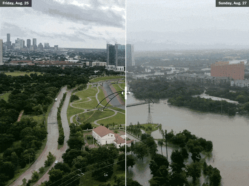
Anywhere it rains it can flood.
We strongly recommend obtaining flood insurance coverage as a safety measure. Interestingly, most of the claims that we have received lately came from areas that were initially considered at low or moderate risk for such disasters. Therefore, it’s better to ensure that you have the right insurance to protect yourself in case of any unexpected flooding that may occur.
Flood Insurance Rate Maps (FIRM)
or Flood Insurance Risk Maps
or Flood Insurance Risk Maps
When purchasing a new home, lenders review FEMA’s Flood Insurance Risk Map to determine whether flood insurance is mandatory under federal law. Any lender who accesses or is backed by federal funds (almost all) requires a Flood Zone Determination (FZD). This official document informs the lender if flood insurance is necessary for your property.
Flood zone AE, Flood zone X, Flood zone VE, and all the others.
FEMA keeps updating flood maps as per new land use, community development or changing weather patterns. While it usually takes 5 years for the changes to become effective, new maps can often be out of date once they are out in the community. If your flood zone has changed from a low to moderate (X Flood Zone) to a higher risk zone (A or AE Flood Zone), it’s important to take notice. Stay informed about newly mapped flood zones to keep yourself prepared against any potential threat.
Previously, if you purchased a flood policy from the NFIP within a calendar year of the effective date of map change, you could enjoy a significantly subsidized policy. However, with the introduction of the Risk Rating 2.0, this option has been eliminated.
If you’re a real estate agent working for a home buyer, consider getting the sellers flood insurance policy for their home. If the seller took advantage of the NFIP new map premium prior to 2.0 they might have a heavily subsidized policy. By getting this policy with a low premium, you can transfer the policy to the new owner and keep the savings. Only someone knowledgable like the Flood Nerds know how to do this. This will take away the burden and risk of purchasing a home in a flood zone. Working with a Flood Nerd can make this process smoother. Don’t hesitate to secure your home and make it more attractive to buyers.
Call a flood nerd to discuss how to if you are considering.
1-866-990-7482
How NFIP rate maps effect your insurance cost.
For half a century, the National Flood Insurance Program (NFIP) has dominated the residential and commercial flood insurance market, with little competition. That’s all about to change though, as private flood insurance companies are using state-of-the-art inland flood modeling tools to offer new, more competitive policies.
Flood risk management and flood risk mapping have long been overseen by the Federal Emergency Management Agency (FEMA), which has created flood risk maps all across the country. These maps serve as valuable guides for disaster preparedness, establish specific guidelines and building codes for structures built after 1973, and are used by the NFIP to set premium rates based on flood zone.
Premium rates for properties mapped in riskier flood zones carry higher rates, while properties located in low-to-moderate flood zones use to receive NFIP subsidized flood policies.
Our findings indicate that the NFIP overcharges half of its policyholders while significantly undercharging the other half, which includes oceanfront properties zoned as low to moderate risk on flood insurance rate maps.
How can this situation be justified? For individuals purchasing flood insurance thought the NFIP, the maps use to play a critical role in assessing premiums and, the NFIP one size fits all model pre risk rating 2.0. Yet, given the significant amount of resources that the government has invested in creating these valuable maps, the frequency of floods beyond designated flood zones and the NFIP’s decision to withhold data collected over its 50-year history raises an important question – why is the NFIP so hesitant to share such valuable information?
Private Flood Insurance Rate Maps
The private flood insurance industry does not rely on the outdated and inadequate maps created by the government. Due to new constructions, buildings, and changes in water flow, relying on these maps may not provide an accurate evaluation of flood risk. The government’s flood insurance program offers a one-size-fits-all solution based on a property’s flood zone. However, the risk of flooding can vary based on several factors such as land typography, land use, soil type, and flood prevention measures taken by the local community. These factors affect the property’s flood risk and determine the cost of flood insurance.
LET US DO THE SHOPPING FOR YOU
What Flood Maps do private market flood insurance companies use?
The private flood insurance market has embraced cutting-edge technology to gain a better understanding of flooding. By leveraging high-resolution data and powerful computers, they now have a better appreciation of the physics behind it.
However, it’s vital not to dismiss the strides made by our government in comprehending flooding. For example, significant progress has been made in understanding how water flows over floodplains, which has enabled the creation of realistic flood models.
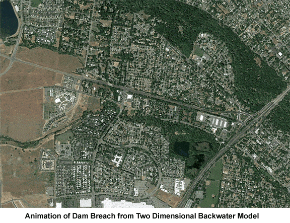
To elaborate on this until the water breaches the river bank, it almost always flows in one direction (downstream). Once it breaks its banks, everything changes; the water flows in many directions. Through laboratory experiments and advanced computer modeling, we’ve gained a better understanding of this multidimensional flow. This knowledge has enabled private flood insurance market to develop precise flood models and generate accurate flood maps.
Hydrology is where I get seriously nerdy. With high-tech computers, extensive data and advanced topography maps, the private sector can now predict floods at a granular level. By integrating advanced satellite and land use information, they can determine flood risk with unprecedented detail. The multidimensional modeling function allows private market flood insurance companies to accurately inspect small-scale changes in flood risk, using complex algorithms to perform flood simulations within seconds. This technology can model flood water at a resolution that was previously impossible. We have come a long way in just a few years, which is evident in the private flood insurance companies’ flood insurance rate maps.